what is rtk technology
Are you ready to optimize your RTK GPS system for maximum results? Look no further! We have gathered some essential information to help you achieve the best possible outcomes.
RTK Systems – Explained
First, let’s discuss what an RTK system is. RTK stands for Real Time Kinematic and it is a method used to enhance the precision of position data derived from satellite-based positioning systems. An RTK GPS system is made up of two components: a base station and a rover. The base station receives signals from GPS, GLONASS or other satellite systems and calculates the precise location of the base station. The rover, which is located at the survey site, receives the signal from the base station and uses it to determine its own location with a very high degree of accuracy. RTK systems are used in precision agricultural applications, surveying, and construction projects, along with many other industries where accurate location data is essential.
Abstract
Optimizing your RTK GPS system is a crucial step in achieving maximum results. By following some best practices, a surveyor can obtain high precision and reliable data for their RTK GPS system. This article provides an overview of RTK systems and offers some tips on how to optimize your system for maximum results.
Introduction
Century-old analog surveying methods have given way to modern technology, making surveys more accurate, efficient, and accessible. One of the most significant advancements has been the utilization of RTK GPS systems. Modern societies rely on technology more than ever before, and the demand for accurate positioning systems has increased significantly in recent decades. Digital surveying systems, such as RTK GPS, have become the norm in the surveying industry due to their high accuracy and proficiency in a variety of applications.
Content
1. Calibration
A proper calibration is essential to the success of an RTK GPS system. Calibration is the process of adjusting the system hardware to ensure that it is measuring as accurately as possible. Each piece of equipment in the system, from the GPS receiver to the antenna, must be calibrated not only for their internal settings but also for external factors such as temperature and atmospheric pressure. While modern GPS systems are generally quite accurate, calibration is necessary to ensure optimal results.
2. Environment
The environment in which you operate your RTK GPS system plays a critical role in the accuracy of your data. The terrain and vegetation in a survey area can significantly affect GPS signals, often negatively impacting the precise positioning required for accurate measurements. To minimize these effects, it’s essential to limit obstructions that may interfere with your system’s ability to communicate with the satellite. It is also helpful to choose periods of low solar activity due to increased solar radiation interference during high levels of activity.
3. Satellite Tracking
RTK GPS systems rely entirely on satellite communication. External factors such as buildings, mountainous terrain, trees, and other obstructions can impede the ability to communicate with satellites, so minimizing obstructions is crucial. It is also essential to track the number of satellites your RTK GPS system is communicating with at any given time. The ideal number of satellites is four or more to correct any positioning errors. Detection of satellite signals can be affected by time, type of equipment used and satellite orbit direction; some GPS manufacturers are developing algorithms to manage signals in difficult reception conditions. It is advisable to keep the batteries on the receiver and antenna full, and the GNSS antenna should be placed with a clear view of the sky for better positioning.
4. Signal and data processing
Signal processing is a crucial element of RTK GPS systems. The system receives signals from the satellite systems and must process these signals quickly to determine position with high accuracy. While modern RTK GPS systems typically process signals accurately, it is always best to use the most up-to-date software available. Data obtained from an RTK GPS system can be large, and it is essential to have a system capable of processing this data with accuracy and speed. Some factors that can affect the system include multi-path effects, noise, and other distortions, but it is important not to have any other interfering wireless devices in the vicinity. The GNSS system needs to support IGS (International GNSS Service) real-time stations.
5. User Training
Use of RTK GPS systems requires specialized training. Like any technology or equipment that is critical to project success, proficiency is essential. However, proficiency is only possible with proper training. Understanding the critical features of your RTK GPS system is crucial to maximizing its potential. It is also essential to keep the user manual handy for reference in the field.
Conclusion
RTK GPS systems are incredibly beneficial in providing accurate and reliable positioning data. Still, to achieve maximum results, it is crucial to optimize your RTK GPS system. By following the recommendations above, you can significantly improve your RTK GPS system’s accuracy and efficiency, which will lead to better operational and business results.

RTK GPS System
The images above feature an RTK GPS system, which can be used to take measurements with extreme accuracy. In addition, the base station of the RTK system can be used in conjunction with the rover to perform RTK surveys. This system is widely used in the surveying and construction spheres for mapping, surveying, and positioning-related tasks.
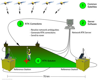
Understanding RTK Systems
Understanding the functionality of the RTK system is crucial in optimizing its performance. The image above provides insight into the function of the RTK system.

Surveying GPS with RTK System
The image above showcases a surveying GPS with an RTK system that can be used in a variety of construction and surveying tasks. It is a rugged, portable and easy-to-use device equipped with dynamic channels providing high sensitivity and tracking performance. It is perfect for professional land surveying, construction layout, and forensic mapping tasks.
Final Thoughts
In conclusion, optimizing your RTK GPS system requires careful calibration, proper training, and mindful operation. A well-calibrated and optimized RTK GPS system will ensure that measurements are taken with precision and accuracy, leading to successful surveying outcomes. Always refer to the user manual when working with your RTK GPS system and ensure you have the most up-to-date software installed for optimal results.
Source image : bench-mark.ca
Source image : www.made-in-china.com
Source image : gssc.esa.int


